The Transformative Influence of Technology on Crop Insurance in India
Guest Author: Mr. Siddesh Ramasubramanian, Fellow Member, Institute of Actuaries of India (IAI)
08 March 2024, New Delhi: With the constant advancement of technology, the agricultural industry in India is going through a major transformation. Among the various changes, crop insurance is a key area that is seeing a remarkable shift. The use of technology has transformed the way insurance companies track and manage crop insurance using Remote Sensing, Satellite Imagery, Data Analytics, and more making it efficient and cost-effective.
This is a positive change for farmers, especially because in the past, they have encountered numerous difficulties related to insuring their crops. For example, the first-ever crop insurance in India was for cotton and was launched by the General Insurance Corporation (GIC) around 1972-73. Post that, while many insurance schemes were launched, it was still a difficult task to scale them up owing to the manual processes involved in enrolment and claim assessment, implementing such schemes is expensive and inefficient. Lack of transparency in the claim assessment process has been another major challenge in the past Schemes.
However, with the infusion of technology, the landscape of crop insurance in India is undergoing a total makeover, resulting in improved accessibility and affordability. This is also evident from the government’s effort to implement technology in crop insurance with schemes such as Pradhan Mantri Fasal Bima Yojana (PMFBY).
The Rise of Technology in the Crop Insurance Sector
In recent years, technology has become a core part of end-to-end crop insurance products helping insurers and the government to implement a diverse range of tools and techniques to help farmers protect their crops. The intersection of actuarial science and technology is reshaping the landscape of crop insurance, heralding a new era of precision, efficiency, and sustainability. As agriculture faces evolving challenges, the integration of advanced technologies and actuarial methodologies has become instrumental in enhancing risk management and ensuring the resilience of crop insurance programs.
Satellite Technology for Crop Monitoring
One of the key technological advancements in the crop insurance sector is the use of satellite imagery to monitor crop fields. Satellite-derived bio-physical parameters help detect vegetation and crop health status. Additionally, this technology aids in predicting climatic risks such as droughts, floods, and pests.
Leveraging satellite data, crop insurance companies gain a more precise analysis of the condition of crops both before and after losses. It allows them to make better and more profitable policies. This heightened accuracy enables them to formulate more effective and profitable insurance policies. Consequently, farmers and agribusiness consultants can leverage the benefits of crop insurance to enhance the quality of agricultural practices and safeguard production from potential losses.
The data collected is compared with historical data categories in indices including Normalized Difference Vegetation Index (NDVI), Land Surface Wetness Index (LSWI), Synthetic Aperture Radar (SAR), Backscatter, Fraction of Photosynthetic Active Radiation (fAPAR), and more. This helps in increasing accuracy for crop monitoring and taking preventive measures for risk mitigation against esteem weather conditions and disasters.
Implementation of Yield Estimation System through Technology:
Implementation of the Yield Estimation System through Technology (YES-TECH) under PMFBY since 2023 aims to bolster the precision and reliability of crop yield estimations essential for PMFBY. The launch of YES-TECH follows the successful implementation of a similar model in the State of West Bengal under the Bangla Sashya Bima (BSB) Scheme since 2020, which is a fully remote-sensing-based claim assessment model. BSB has been successful in enabling swift and accurate claim payments to farmers right after their losses when the claim amount is most needed by them to restart their agricultural practice.
By marrying technology-driven methodologies with conventional crop-cutting experiments (CCEs), YES-TECH seeks to refine the insurance claim assessment process. This strategy is anticipated to enable prompt and accurate compensation to farmers for crop losses, fostering increased participation in the scheme and bolstering the agricultural sector’s resilience to adverse events.
As YES-TECH significantly relies on the satellite imagery data collected at granular levels, the quantity and quality of such data plays a huge role in the successful implementation of this initiative. The Sentinel-1 and Sentinel-2 satellites of the European Space Agency (ESA) are pivotal in crop insurance for supplying high-resolution spatial and temporal data. Sentinel-1, with its radar imaging, facilitates all-weather, day-and-night monitoring, ideal for observing crop growth and moisture levels. Whereas, Sentinel-2 contributes high-resolution optical imagery, crucial for evaluating vegetation health and distinguishing crop types. Together, they provide unparalleled spatial resolutions (up to 20m for Sentinel-1 and 10m for Sentinel-2) and frequent revisits (every 12 days/5 days for Sentinel-1 and Sentinel-2, respectively), enhancing the precision of crop loss assessment efficiently and transparently. Access to Sentinel data is offered free of charge, promoting its extensive use in agricultural monitoring and insurance applications.
Implementation of National Weather Information Network & Data System
Another major initiative of the Government of India is the implementation of the National Weather Information Network & Data System (WINDS) which aims to set up a national network of Automatic Weather Stations (AWSs) and Automatic Rain Gauges (ARGs) at granular levels to capture accurate weather data at real-time. This national data will have wide-ranging applications in the fields of crop insurance, sowing, cropping, harvesting, market planning, and providing timely crop advisories to farmers. Apart from this, the WINDS network will also nurture further research and development in other related fields for wider application and strategic utilization across multiple sectors of the economy.
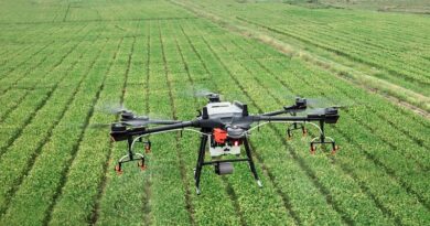
Usage of Unmanned Aerial Vehicles: Unmanned Aerial Vehicles (UAVs) or Drones have emerged as valuable tools in assessing crop damage and estimating crop losses. Equipped with high-resolution cameras and sensors, drones can capture detailed images of agricultural fields, providing real-time information on crop health/damage. Insurers can use this information to accurately assess the extent of crop losses caused by natural disasters, pests, diseases, or other factors without physical inspections, which can be time-consuming and costly. Drones can cover a large area of farmland quickly and efficiently, capturing images from different angles and heights. By combining this data with satellite imagery and weather-based indices, complete crop health information products can also be developed.
Data Analytics For Faster Claim Settlement
Data analytics has emerged as a game-changer in the crop insurance sector. Large volumes of data streams on crops are now available from various sources such as satellites, weather stations, and mobile applications. This makes it easier for insurers to check the correctness of data during the entire policy lifecycle from enrolment to loss assessment.
Insurers can now corroborate enrolment under crop insurance Schemes with satellite imagery data to identify cases of over-insurance or insurance of the wrong crop. Modern data analytics tools also provide a quick assessment of data to identify duplicate enrolments thereby further reducing over-insurance.
In the past, claim assessment relied only on manual crop-cutting experiments, which were prone to sampling and non-sampling bias. However, with the availability of extensive data on crop health indicators, it is now possible to develop more accurate and objective assessments of crop losses. This can be used to increase the insurance settlement process between insurers and farmers.
On Actuarial Techniques for Crop Loss Modelling
Advanced statistical and computational methods are utilized in Actuarial Techniques for crop loss modeling to assess agricultural risks and damages. The entropy method, a non-parametric approach, analyses variability in RST-based data to assign weights to each RST parameter, attributing greater importance to parameters that introduce more information, thus offering a solid framework for insurance assessments without presuming a specific data distribution. Conversely, Machine Learning (ML) models, and other parametric models, exploit historical data and recognizable patterns to predict crop yields and losses with increasingly accurate outcomes over time. By leveraging a variety of data analysis techniques, these methodologies furnish sophisticated tools for crafting precise and adaptable crop insurance models.
Conclusion: What does the future hold?
There has already been a rise in the number of technology-driven crop insurance initiatives by Insurtech players as well as the Indian government, showcasing the transformative potential of these advancements. For example, the Pradhan Mantri Fasal Bima Yojana (PMFBY) through YES-Tech focuses on providing affordable crop insurance to farmers by using technology such as remote sensing, satellite imagery, mobile apps, and more to accurately assess crop losses and provide timely compensation to farmers.
The government of India is also promoting insurance companies to launch new innovative products based on technology solutions under the PMFBY Sandbox. This would not only drive innovation but also offer a single source platform for farmers to access such products thereby making it easier to scale up these products.
As technology continues to evolve, the outlook for the future of crop insurance appears promising. Insurers are poised to provide more accurate risk assessments, faster claims settlement, and customized insurance products. For farmers, these developments translate into enhanced accessibility, affordability, and transparency within the insurance process. This, in turn, empowers farmers to manage risks more effectively, thereby stabilizing their income. Ultimately, these technological strides contribute to fostering sustainability in the Indian agriculture ecosystem and ensuring the livelihoods of farmers.
Also Read: Coromandel’s Gromor Drive Crosses 16,000+ acres of Drone-led Spraying
(For Latest Agriculture News & Updates, follow Krishak Jagat on Google News)
