Harnessing new high-resolution satellite imagery to plant breeding
New study by CIMMYT researchers shows how multi-temporal, high-resolution satellite images can be used effectively to monitor breeding maize and wheat breeding plots in diverse environments.
07 September 2023, Zimbabwe: In plant breeding, efforts to increase the rate of genetic gains and enhance crop resilience to the effects of climate change are often limited by the inaccessibility and costs of phenotyping methods. The recent rapid development of sensors, image-processing technology and data analysis has provided new opportunities for multiple scales phenotyping methods and systems. Among these, satellite imagery may represent one of the best ways to remotely monitor trials and nurseries planted in multiple locations, while standardizing protocols and reducing costs.
This is because relevant data collected as part of crop phenotyping can be generated from satellite images. For instance, the sensors onboard the SkySat satellite constellation of Planet Labs have four spectral bands—blue, green, red, and infrared—which can be used to calculate the normalized difference vegetation index (NDVI), which is a measure of vegetation and its greenness, and various canopy traits like ground cover, leaf area index and chlorosis. It can also be used to monitor plot establishment and phenological parameters.
The use of satellite-based phenotyping in breeding trials has typically been restricted by low resolution, high cost and long intervals between fly-overs. However, the advent of a new generation of high-resolution satellites—such as the SkySat constellation—now offers multispectral images at a 0.5m resolution with close to daily acquisition attempts on any place on Earth. This could be a game changer in terms of the scale at which yield trials can be conducted, enabling more precise variety placement and thereby increasing genetic diversity across farmer’s fields and reducing the probability of disease epidemics. It could also revolutionize the capacity for research in realistic field conditions, since traits can be measured throughout the cycle in a highly standardized way, over multiple sites at low cost. For example, an image which covers 25 km2 can monitor an entire research station at a cost of about US$300.
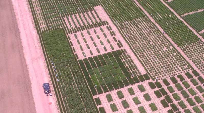
To test the suitability of this technology, a team of researchers from CIMMYT set out to evaluate the reliability of SkySat NDVI estimates for maize and wheat breeding plots of different sizes and spacing, as well as testing its capacity for detecting seasonal changes and genotypic differences.
Both their initial findings, recently published in Frontiers in Plant Science, and more recently acquired data, show that the SkySat satellites can be used to monitor plots commonly used in wheat and maize nurseries. While wheat yield plots usually are 1.2m wide, maize plots tend to consist of at least two rows, resulting in a width of 1.5m. Plot length ranges from 2-4m. The authors also discuss on other factors to be considered when extracting and interpreting satellite data from yield trials, such as plot spacing.
Through the successful collection of six satellite images in Central Mexico during the rainy season and parallel monitoring of a maize trial in Zimbabwe, the researchers demonstrate the flexibility of this tool. Beyond the improvement of spatial resolution, the researchers suggest that the next challenge will be the development and fine-tuning of operational procedures that ensure high quality, standardized data, allowing them to harness the benefits of the modern breeding triangle, which calls for the integration of phenomics, enviromics and genomics, to accelerate breeding gains.
Also Read: Swaraj launches 5 new tractors in the 40 to 50 HP category; Onboards MS Dhoni as brand ambassador
(For Latest Agriculture News & Updates, follow Krishak Jagat on Google News)