Licensing agreement with HL Hutchinsons (HLH) signed to supply farmers with precision soil analysis service
Interra® Scan offers one of the world’s highest resolution soil mapping services to optimize nutrition and carbon capture
Major step towards regenerative agriculture, underlining Syngenta’s commitment to improve soil health
28 July 2022, Switzerland: Syngenta has signed a licensing agreement with UK based HL Hutchinsons (HLH) to supply agronomists and farmers with an advanced soil mapping and sampling service initially in continental and Eastern Europe. It will be marketed under the name Interra® Scan and enables agronomists and growers to make better informed decisions for crop management and soil stewardship.
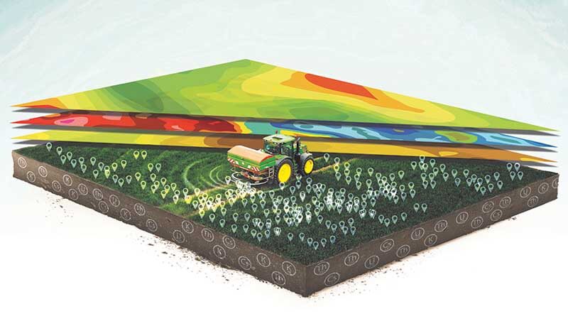
Interra® Scan offers high-resolution soil mapping up to 27 layers of information, providing growers with precise information on soil health. “It allows growers to understand the texture, nutrient and carbon content of their soils in order to optimize nutrition and carbon capture”, explains Mark Hall, Head of Sustainable and Responsible Business EAME. “Interra® Scan takes over 800 data reference points per hectare, showing more details and geospatial differences than other mapping techniques such as drones, satellites, or grid sampling. Interra® Scan can be described as the equivalent of an all-round medical check-up for humans, but for soil.”
This agreement is proof of Syngenta’s commitment to help growers create healthy soils which are the foundation of our food system. They also have a critical role to play as a natural carbon sink to help meet the Paris Climate Agreement. “Finally, soil health is plant health. This is why we are investing into innovative solutions like Interra® Scan. In the past, growers would treat the entire field in the same way. With Interra® Scan, they know exactly what to apply where and how much of it, making the most of precision technology”, says Alexandra Brand, Regional Director EAME. “As an additional benefit, growers can optimize input costs on fertilizers, seeds and lime which is even more important in the current economic situation. We can clearly say Interra® Scan is a win-win situation for farmers and the environment.”
The in-field process of collecting data includes two steps: First, the soil is scanned with gamma-ray detection technology by SoilOptix® to map all of the common nutrient and physical soil properties and physical soil samples are collected. The raw scan, soil data and soil samples are then combined and processed to produce up to 27 high-definition soil property layers. Growers have easy on-the-go access via a digital platform to view the results in a unique soil properties map and develop variable rate application maps for their crop input applications.